
Dispatching Built for Animal Control
Manage calls for service, officer assignments, field response, mapping, routing, and officer safety from one connected operational workspace.
MultiOp Dispatching brings call-center staff, dispatchers, supervisors, and field officers together around the same complaint and operational record. Agencies can support centralized dispatch, officer self-dispatch, or a combination of both.
See the Entire Operation at a Glance
Calls, units, assignments, mapping, safety information, field activity, and follow-up remain connected throughout the response.
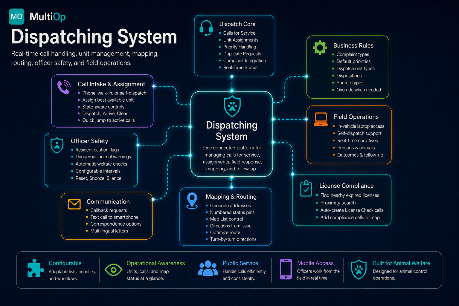
Click image to enlarge.
MultiOp Dispatching combines call handling, officer status, mapping, safety tools, field operations, and connected records in a single system.
From Incoming Call to Field Response
Calls for service can be entered directly by dispatch or created first in the MOASMS Complaints module by call-center staff. When field response is required, the call can be sent to Dispatching without re-entering the information.
Calls may be viewed individually in Form view or together in a sortable Datasheet view, giving dispatchers an immediate picture of the active workload.
Call Intake
Record received date and time, source, complaint type, priority, location, duplicate requests, persons, animals, narratives, and other incident information.
Flexible Assignment
Assign calls to officers for immediate response or future workload. Assigning a call informs the unit without necessarily placing the officer en route.
State-Aware Workflow
Available, Dispatched, and Out-of-Service unit lists automatically control which actions are valid. The system prevents actions such as dispatching a unit already on a call or marking a unit arrived before it has been dispatched.
Fast Navigation
Double-click a dispatched unit or Map List entry to jump directly to the associated call.
Default Priorities with Override
Complaint types can carry agency-defined default priorities while allowing dispatcher judgment to override the priority when circumstances require it.
Status Changes Stay Synchronized
A simple operational workflow keeps the dispatcher informed without unnecessary data entry.
Operational Mapping Designed for Field Work
Mapping is integrated directly with the Dispatching workflow rather than being a separate application requiring duplicate address entry.
Geocoding
Geocode a complaint address and place the call on the operational map.
Status-Aware Markers
Numbered, color-coded markers identify call status. The marker number corresponds to the Dispatching Map List.
- Green — Received
- Yellow — Assigned
- Orange — Dispatched / En Route
- Red — Arrived / On-Site
Interactive Map List
Mapped calls appear in the Map List. Dispatchers can jump directly to a call, center it on the map, or add it to a route.
Route Management
Build multi-stop routes from active calls. Arrange stops manually or allow the system to optimize the sequence.
Turn-by-Turn Directions
Generate directions, travel distance, and estimated travel time directly from Dispatching.
Directions from Base
Generate a route from the agency's configured base location with a single action.
Traffic
Display current Google traffic information when useful.
Reverse Geocoding
Right-click a location on the map to determine the associated street address. This has proven particularly useful during real-world field operations.
Local Search
Find nearby resources such as fuel, ATMs, veterinary facilities, stores, addresses, or other locations without leaving the map.
Distance Measurement
Measure straight-line distance between map locations.
Coordinates
Display current latitude/longitude dynamically and save selected map coordinates.
Additional Map Tools
Map/Satellite views, Street View, bounding-box zoom, configurable right-click behavior, map scale, and expandable map viewing area.
Give Officers More Information Before They Arrive
Dispatching can surface important location history before an officer reaches the scene. Residents and animals associated with the address can carry visual caution indicators, helping dispatchers identify known concerns.
Resident Caution Flags
Highlight people associated with the location who have been flagged for caution.
Dangerous Animal Warnings
Identify animals with important behavioral or safety warnings.
Call History
Review previous calls associated with the location directly from the active dispatch record.
Residents & Animals
See people and animals associated with the address without leaving the call.
Automatic Officer Welfare Monitoring
When an officer goes On-Site, MultiOp can automatically start a welfare timer using an agency-configurable interval. Dispatchers can see active welfare monitoring directly from the Dispatching screen and on the map.
When a welfare check becomes due or overdue, Dispatching presents a prominent alert identifying the unit and call.
Welfare status is stored in SQL Server, so active checks survive closing and reopening Dispatching. Map information can display remaining or overdue welfare time for each on-site unit, while the Welfare Monitor indicator shows the number of active checks being tracked. The welfare architecture is also designed to work with future AOTS officer-location and last-contact capabilities.
Dispatchers and Officers Work from the Same Record
Many animal control officers work from laptops in their vehicles. MultiOp supports centralized dispatch, officer self-dispatch, and blended workflows.
Field officers can access active calls and update complaint information while they work, including narratives, associated persons, animals, dispositions, citations, follow-up information, and other incident details. Because Dispatching and Complaints use the same underlying MOASMS records, information entered in the field does not need to be re-entered by dispatch staff.
Explore Mobile & Web ToolsCommunication Tools Built into the Call
Dispatching provides practical communication options around the active call, including callback tracking, telephone information, smartphone call details, correspondence, and follow-up.
Some routine complaints may be resolved administratively through correspondence rather than consuming field resources. For example, a call-center employee receiving a routine barking-dog complaint may use an agency-defined Barking Dog Letter instead of dispatching an officer when policy permits.
Turn Officer Downtime into Productive Compliance Activity
For organizations using the MultiOp Licensing System, Dispatching can identify nearby addresses with animals that have missing or expired licenses. Staff can specify a proximity, review the results, select appropriate records, and automatically create License Check complaints that are added to the map for field follow-up.
This gives officers useful nearby activity during slower periods while helping improve license compliance, licensing revenue, and the quality of animal and owner records. Proper licensing can also help agencies maintain information such as rabies vaccination status and animal identification records.
Explore License ManagementConfigured Around the Way Your Agency Works
MultiOp does not force every animal control organization into the same workflow. Administrative settings allow Dispatching and Complaints to reflect agency terminology, policies, priorities, and operating procedures.
Default values assist staff but can be overridden where operational judgment requires it.
Turn Dispatch Activity into Useful Management Information
MOASMS includes an easy-to-use, criteria-driven reporting framework for operational and management reporting. Rather than requiring a separate fixed report for every question, individual reports can expose relevant criteria such as date ranges, complaint types, officers, statuses, locations, or other selections.
Criteria-driven reporting lets one report answer many different questions.
Dispatching Ends. The Case Can Continue.
Most routine calls complete their dispatch lifecycle and are then closed. More complex matters, such as animal abuse investigations, may remain active in the MOASMS Complaints and Case Management system after the immediate field response is complete. Those cases can be managed over time and dispatched again when additional field activity is required.
Dispatching
Manages the operational field-response portion of the incident — call intake, assignment, mapping, response status, and safety monitoring through to Cleared.
MOASMS Case Management
Manages longer-running investigations, follow-up, documentation, and case resolution for matters that continue after the initial field response.
More Powerful Because It Is Part of MOASMS
Dispatching draws on the same connected records used across MOASMS — so calls, animals, people, licenses, and history stay linked instead of scattered across disconnected systems.
Complaint & Case Management
One underlying incident record from intake through follow-up, shared between Dispatching and the Complaints module.
Explore Animal Control →License Management
Use licensing information during field operations and proactively identify compliance opportunities.
Explore License Management →Animal & Owner Records
Connect animals, people, addresses, cautions, and history shared with the shelter management module.
Explore Shelter Software →Mobile / Field Tools
Connect Dispatching with MultiCapture and future AOTS capabilities.
Explore Mobile Tools →Reporting & Management
Use operational dispatch data for management review and accountability.
See All Features →Common Questions
Questions we hear from dispatchers, field supervisors, and animal control administrators evaluating dispatching software.
Can officers self-dispatch?
Yes. MultiOp supports centralized dispatch, self-dispatch, and blended workflows. Officers working from vehicle laptops can review calls and update the same complaint records used by dispatch staff.
Can Dispatching show previous activity at an address?
Yes. Dispatchers can review prior calls as well as residents and animals associated with the location. Caution indicators can highlight known safety concerns.
Does MultiOp include mapping and routing?
Yes. Dispatching includes geocoding, mapped calls, color-coded status markers, route building, route optimization, directions, reverse geocoding, local search, traffic, and other map tools.
How do officer welfare checks work?
When a unit goes On-Site, a configurable welfare timer can start automatically. When a check becomes due or overdue, Dispatching alerts the operator and provides controls to reset, snooze, silence, or disable the check as appropriate.
Does Dispatching work with pet licensing?
For agencies using MultiOp License Management, Dispatching can locate nearby unlicensed or expired-license animals and create mapped License Check complaints for field follow-up.
Does every dispatched complaint become a long-term case?
No. Most calls complete the dispatch process and are closed. Incidents requiring extended investigation or follow-up can continue in MOASMS Case Management and can be dispatched again when additional field response is necessary.
See MultiOp Dispatching in Action
See how MultiOp can bring calls for service, officer assignments, mapping, safety tools, field activity, and management information together for your animal control operation.